A tool made by grad students is the ultimate “geoguesser,” using its knowledge of Google Street View to track down any photo’s location.
Category: mapping – Page 35
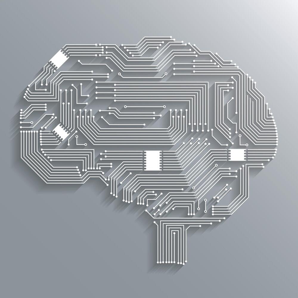
This Machine Learning Research Opens up a Mathematical Perspective on the Transformers
The release of Transformers has marked a significant advancement in the field of Artificial Intelligence (AI) and neural network topologies. Understanding the workings of these complex neural network architectures requires an understanding of transformers. What distinguishes transformers from conventional architectures is the concept of self-attention, which describes a transformer model’s capacity to focus on distinct segments of the input sequence during prediction. Self-attention greatly enhances the performance of transformers in real-world applications, including computer vision and Natural Language Processing (NLP).
In a recent study, researchers have provided a mathematical model that can be used to perceive Transformers as particle systems in interaction. The mathematical framework offers a methodical way to analyze Transformers’ internal operations. In an interacting particle system, the behavior of the individual particles influences that of the other parts, resulting in a complex network of interconnected systems.
The study explores the finding that Transformers can be thought of as flow maps on the space of probability measures. In this sense, transformers generate a mean-field interacting particle system in which every particle, called a token, follows the vector field flow defined by the empirical measure of all particles. The continuity equation governs the evolution of the empirical measure, and the long-term behavior of this system, which is typified by particle clustering, becomes an object of study.
From Blacksmiths to Beamlines: 3D Atomic Revelations Transform Alloy Engineering
UCLA breaks new ground in alloy research, presenting the first 3D mapping of medium and high-entropy alloys, potentially revolutionizing the field with enhanced toughness and flexibility in these materials.
Alloys, which are materials such as steel that are made by combining two or more metallic elements, are among the underpinnings of contemporary life. They are essential for buildings, transportation, appliances and tools — including, very likely, the device you are using to read this story. In applying alloys, engineers have faced an age-old trade-off common in most materials: Alloys that are hard tend to be brittle and break under strain, while those that are flexible under strain tend to dent easily.
Advancements in Alloy Research.
Aeromao introduces the world’s first water-landing fixed-wing drone
It features a sleek aerodynamic design, no tilt mechanisms or extra parts, eliminating failures and unnecessary weight for efficient vertical flight.
The innovative aerial solution is ideal for high-precision mapping to agriculture, ensuring efficient coverage in every flight.

Tesla navigation adds speed camera awareness and more in update
Tesla’s vehicles can now recognize speed cameras as of its latest update, along with several other navigation features that will reportedly be coming soon.
Code sleuth and Tesla update observer Greentheonly said on Sunday that Tesla software update 2023.27.12 has added the speed camera awareness feature along with other camera awareness capabilities. The update includes the Full Self-Driving (FSD) beta version 11.4.8.1, and it was first spotted in a Tesla vehicle on Saturday, according to Teslascope.
The software update also includes red light camera awareness, including those for fixed and mobile versions, and a combined awareness for red lights and speed cameras. Green also says that several other navigation features appear to be right around the corner, including U-turn control and an “avoid construction on route” setting, as found in internal code for Tesla’s maps system.
A new quantum algorithm for classical mechanics with an exponential speedup
Quantum computers promise to solve some problems exponentially faster than classical computers, but there are only a handful of examples with such a dramatic speedup, such as Shor’s factoring algorithm and quantum simulation. Of those few examples, the majority of them involve simulating physical systems that are inherently quantum mechanical — a natural application for quantum computers. But what about simulating systems that are not inherently quantum? Can quantum computers offer an exponential advantage for this?
In “Exponential quantum speedup in simulating coupled classical oscillators”, published in Physical Review X (PRX) and presented at the Symposium on Foundations of Computer Science (FOCS 2023), we report on the discovery of a new quantum algorithm that offers an exponential advantage for simulating coupled classical harmonic oscillators. These are some of the most fundamental, ubiquitous systems in nature and can describe the physics of countless natural systems, from electrical circuits to molecular vibrations to the mechanics of bridges. In collaboration with Dominic Berry of Macquarie University and Nathan Wiebe of the University of Toronto, we found a mapping that can transform any system involving coupled oscillators into a problem describing the time evolution of a quantum system. Given certain constraints, this problem can be solved with a quantum computer exponentially faster than it can with a classical computer.
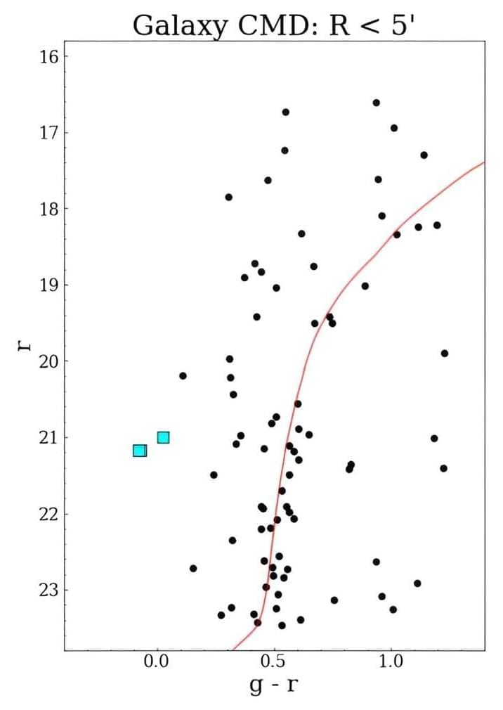
KiDS in the sky: New Stellar system discovered by the Kilo-Degree Survey
Astronomers have discovered a new stellar system in the outskirts of the Milky Way as part of the Kilo-Degree Survey (KiDS). The newfound system, named Sextans II, is most likely an ultra-faint dwarf galaxy. The finding is reported in a paper published November 10 on the pre-print server arXiv.
KiDS is an extensive multi-band photometric survey utilizing the VLT Survey Telescope (VST) at ESO’s Paranal Observatory in Chile. Since 2011, the survey has been mapping 1,350 square degrees of the night sky in four broad-band filters (u, g, r, i). Although KiDS is focused on the assembly of large-scale structures in the universe, it may also detect low-surface brightness extragalactic stellar systems.
That is why a team of astronomers led by Massimiliano Gatto of the Astronomical Observatory of Capodimonte in Naples, Italy, decided to conduct a large-scale search for unknown faint stellar systems with KiDS. For this purpose, they looked for low-luminosity stellar overdensities in the KiDS latest data release (DR4), which brought promising results.
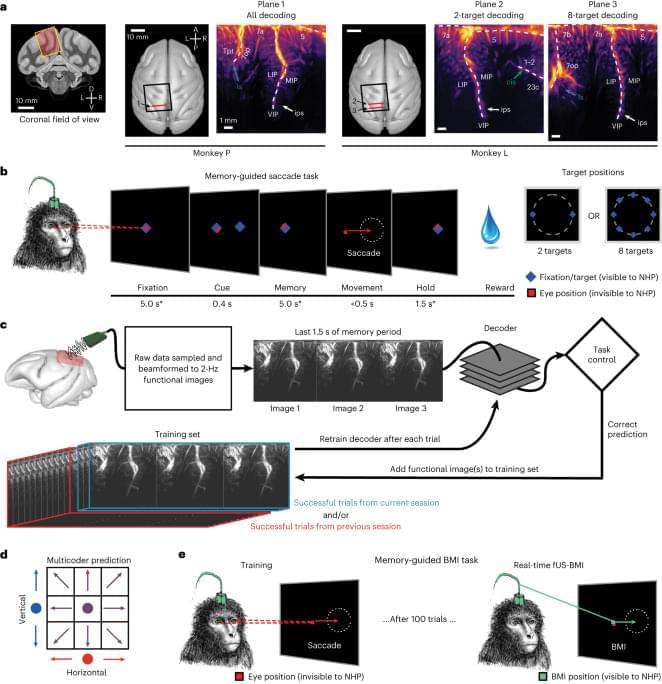
Decoding motor plans using a closed-loop ultrasonic brain–machine interface
BMIs using intracortical electrodes, such as Utah arrays, are particularly adept at sensing fast changing (millisecond-scale) neural activity from spatially localized regions (1 cm) during behavior or stimulation that is correlated to activity in such spatially specific regions, for example, M1 for motor and V1 for vision. Intracortical electrodes, however, struggle to track individual neurons over longer periods of time, for example, between subsequent recording sessions15,16. Consequently, decoders are typically retrained every day15. A similar neural population identification problem is also present with an ultrasound device, including from shifts in the field of view between experiment sessions. In the current study, we demonstrated an alignment method that stabilizes image-based BMIs across more than a month and decodes from the same neurovascular populations with minimal, if any, retraining. This is a critical development that enables easy alignment of a previous days’ models to a new day’s data and allows decoding to begin with minimal to no new training data. Much effort has focused on ways to recalibrate intracortical BMIs across days that do not require extensive new data18,19,20,21,22,23. Most of these methods require identification of manifolds and/or latent dynamical parameters and collecting new neural and behavioral data to align to these manifolds/parameters. These techniques are, to date, tailored to each research group’s specific applications with varying requirements, such as hyperparameter tuning of the model23 or a consistent temporal structure of data22. They are also susceptible to changes in function in addition to anatomy. For example, ‘out-of-manifold’ learning/plasticity alters the manifold24 in ways that many alignment techniques struggle to address. Finally, some of the algorithms are computationally expensive and/or difficult to implement in online use22.
Contrasting these manifold-based methods, our decoder alignment algorithm leverages the intrinsic spatial resolution and field of view provided by fUS neuroimaging to perform decoder stabilization in a way that is intuitive, repeatable and performant. We used a single fUS frame (∼ 500 ms) to generate an image of the current session’s anatomy and aligned a previous session’s field of view to this single image. Notably, this did not require any additional behavior for the alignment. Because we only relied upon the anatomy, our decoder alignment is robust, can use any off-the-shelf alignment tool and is a valid technique so long as the anatomy and mesoscopic encoding of relevant variables do not change drastically between sessions.
It remains an open question as to how much the precise positioning of the ultrasound transducer during each session matters for decoder performance, especially out-of-plane shifts or rotations. In these current experiments, we used linear decoders that assumed a given image pixel is the same brain voxel across all aligned data sessions. To minimize disruptions to this pixel–voxel relationship, we performed image alignment within the 2D plane. As we could only image a 2D recording plane, we did not correct for any out-of-plane brain shifts between sessions that would have disrupted the pixel–voxel mapping assumption. Future fUS-BMI decoders may benefit from three-dimensional (3D) models of the neurovasculature, such as registering the 2D field of view to a 3D volume25,26,27 to better maintain a consistent pixel–voxel mapping.
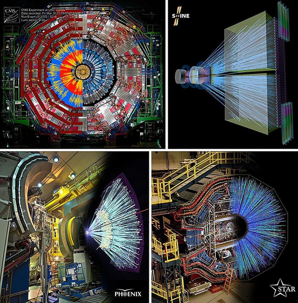
Using the world’s three most powerful particle accelerators to reveal the space-time geometry of quark matter
Physicists from the Eötvös Loránd University (ELTE) have been conducting research on the matter constituting the atomic nucleus utilizing the world’s three most powerful particle accelerators. Their focus has been on mapping the “primordial soup” that filled the universe in the first millionth of a second following its inception.
Intriguingly, their measurements showed that the movement of observed particles bears resemblance to the search for prey of marine predators, the patterns of climate change, and the fluctuations of stock market.
In the immediate aftermath of the Big Bang, temperatures were so extreme that atomic nuclei could not exists, nor could nucleons, their building blocks. Hence, in this first instance the universe was filled with a “primordial soup” of quarks and gluons.